لیونورت (کانزاس)
Leavenworth, Kansas | |
|---|---|
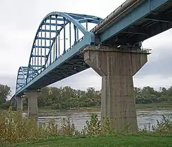 Centennial Bridge over the رودخانه میزوری between Leavenworth and شهرستان پلت، میزوری, 2006 | |
 مهر | |
| شعار: The first city of Kansas | |
 | |
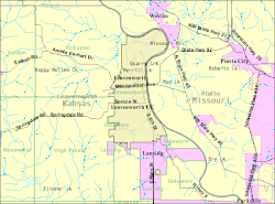 U.S. Census Map | |
| مختصات: ۳۹°۱۸′۴۰″ شمالی ۹۴°۵۵′۲۱″ غربی / ۳۹٫۳۱۱۱۱°شمالی ۹۴٫۹۲۲۵۰°غربی | |
| کشور | آمریکا |
| ایالات آمریکا | کانزاس |
| شهرستان | Leavenworth |
| Founded | ۱۸۵۴ |
| Incorporated | ۱۸۵۵ |
| مساحت | |
| • کل | ۲۴٫۰۶ مایل مربع (۶۲٫۳۲ کیلومتر مربع) |
| • خشکی | ۲۴٫۰۴ مایل مربع (۶۲٫۲۶ کیلومتر مربع) |
| • آب | ۰٫۰۲ مایل مربع (۰٫۰۵ کیلومتر مربع) |
| ارتفاع | ۸۴۰ فوت (۲۵۶ متر) |
| جمعیت | |
| • کل | ۳۵۲۵۱ |
| • برآورد (۲۰۱۱[۳]) | ۳۵۶۷۵ |
| • تراکم | ۱۴۶۶٫۳/مایل مربع (۵۶۶٫۱/کیلومتر مربع) |
| منطقهٔ زمانی | یوتیسی -۶ (Central (CST)) |
| • تابستانی (DST) | یوتیسی -۵ (CDT) |
| زیپکد | ۶۶۰۴۳, ۶۶۰۴۸ |
| کد منطقه | ۹۱۳ |
| FIPS کد | ۲۰-۳۹۰۰۰[۴] |
| GNIS feature ID | ۰۴۷۸۴۱۱[۵] |
| وبگاه | www.LVKS.org |
لیونورت (به انگلیسی: Leavenworth) شهری در ایالت کانزاس کشور ایالات متحده آمریکا است که جمعیت آن در سرشماری سال ۲۰۱۰ میلادی، ۳۵٬۲۵۱ نفر بودهاست.[۶]
نگارخانه

جستارهای وابسته
منابع
- ↑ "US Gazetteer files 2010". United States Census Bureau. Archived from the original on 14 July 2012. Retrieved 2012-07-06.
- ↑ "American FactFinder". United States Census Bureau. Retrieved 2012-07-06.
{{cite web}}: External link in|publisher= - ↑ "Population Estimates". United States Census Bureau. Archived from the original on 18 September 2012. Retrieved 2013-01-03.
{{cite web}}: External link in|publisher= - ↑ "American FactFinder". اداره آمار آمریکا. Retrieved 2008-01-31.
- ↑ "US Board on Geographic Names". سازمان نقشهبرداریهای زمینشناسی آمریکا. 2007-10-25. Retrieved 2008-01-31.
- ↑ "kansas" (به انگلیسی). factfinder2.census. Retrieved 29 Jan 2013.
ح. ۱۶۵۰ تا ۱۹۱۲ | |||||||||||||||||||||||||||||||||||||||||||
| افراد برجسته |
| ||||||||||||||||||||||||||||||||||||||||||
| بومیان آمریکا |
| ||||||||||||||||||||||||||||||||||||||||||
| فرهنگ سرحدی |
| ||||||||||||||||||||||||||||||||||||||||||
| حملونقل و مسیرها |
| ||||||||||||||||||||||||||||||||||||||||||
| فلکور |
| ||||||||||||||||||||||||||||||||||||||||||
| تب طلا |
| ||||||||||||||||||||||||||||||||||||||||||
| نبرد مسلحانه |
| ||||||||||||||||||||||||||||||||||||||||||
| درگیریها |
| ||||||||||||||||||||||||||||||||||||||||||
| Range wars and جنگها |
| ||||||||||||||||||||||||||||||||||||||||||
| فهرستها |
| ||||||||||||||||||||||||||||||||||||||||||
| تأثیرات |
| ||||||||||||||||||||||||||||||||||||||||||
| |||||||||||||||||||||||||||||||||||||||||||
| |||||||||||||||||||||||||||||||||||||||||||