کالدرا دل آتوئل
| کالدرا دل آتوئل | |
|---|---|
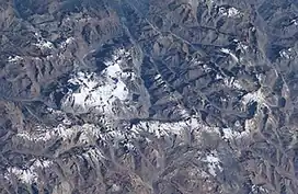 A complex of snow-covered cones (left-center) partially fills the 30 x 45 km wide Caldera del Atuel, which lies just east of the Argentina-Chile border. The headwaters of the Río del Atuel drain to the SE through a wide breach in the caldera rim (top center) in this NASA International Space Station image (with north to the bottom left). The snow-covered Volcán Overo and Sosneado complexes in the eastern part of the caldera contain numerous very youthful basaltic-to-andesitic pyroclastic cones and lava flows. | |
| مرتفعترین نقطه | |
| ارتفاع | ۵٬۱۸۹ متر (۱۷٬۰۲۴ فوت) |
| مختصات | ۳۴°۳۹′جنوبی ۷۰°۰۳′غربی / ۳۴٫۶۵°جنوبی ۷۰٫۰۵°غربی |
| جغرافیا | |
| موقعیت | استان مندوسا، آرژانتین |
| رشتهکوه مادر | کوههای آند |
| زمینشناسی | |
| نوع کوه | کاسه آتشفشانی |
| آخرین فوران | Unknown |
کالدرا دل آتوئل (به اسپانیایی: Caldera del Atuel) یک کوه در آرژانتین است.[۱][۲] کالدرا دل آتوئل ۵٬۱۸۹ متر بالاتر از سطح دریا واقع شدهاست.
جستارهای وابسته
منابع
- ↑ Völker, David; Kutterolf, Steffen; Wehrmann, Heidi (August 2011). "Comparative mass balance of volcanic edifices at the southern volcanic zone of the Andes between 33°S and 46°S". Journal of Volcanology and Geothermal Research. 205 (3–4): 114–129. doi:10.1016/j.jvolgeores.2011.03.011.
- ↑ "Volcanes Activos" (PDF). www.ign.gob.ar (in Spanish). Instituto Geográfico Nacional (Argentina). Retrieved 28 January 2016.
پیوند به بیرون

در ویکیانبار پروندههایی دربارهٔ کالدرا دل آتوئل موجود است.
ردهها:
- آتشفشانهای چندزادی
- کاسههای آتشفشانی آمریکای جنوبی
- کوههای آرژانتین
- کوههای پنج هزار متری آند