تامپسون، منیتوبا
تامپسون، منیوبا | |
|---|---|
شهر | |
| تامپسون، منیوبا | |
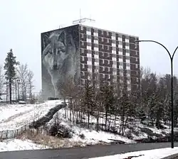 Highland Tower, chosen for the Spirit Way wolf mural, is the most prominent building on Thompson's skyline | |
| نامهای مستعار: | |
 تامپسون، منیوبا موقعیت در منیوبا | |
| مختصات: ۵۵°۴۴′۳۶″ شمالی ۹۷°۵۱′۱۹″ غربی / ۵۵٫۷۴۳۳۳°شمالی ۹۷٫۸۵۵۲۸°غربی | |
| کشور | Canada |
| استان | Manitoba |
| Region | Northern Region |
| Census division | 22 |
| تأسیسشده | ۱۹۵۶ |
| ثبتشده | ۱۹۶۷ شهرک |
| حکومت | |
| • شهردار | دنیس فنسکه |
| • Governing Body | Thompson City Council |
| • MLA (Thompson) | Thompson City Council |
| • MP (Churchill) | نیکی اشتون (NDP) |
| مساحت | |
| • کل | ۱۷٫۱۸ کیلومتر مربع (۶٫۶۳ مایل مربع) |
| • Census Agglomeration | ۳۴۸۱٫۲۴ کیلومتر مربع (۱۳۴۴٫۱۱ مایل مربع) |
| جمعیت (۲۰۱۱) | |
| • کل | ۱۳۱۲۳ |
| • تراکم | ۷۸۲٫۸/کیلومتر مربع (۲۰۲۷/مایل مربع) |
| • Census Agglomeration | ۱۳۱۲۳ |
| • تراکم Census Agglomeration | ۳٫۷/کیلومتر مربع (۱۰/مایل مربع) |
| اهلیتنام | Thompsonnite |
| منطقهٔ زمانی | یوتیسی −۶ (CST) |
| • تابستانی (DST) | یوتیسی −۵ (CDT) |
| کد پستی | R8N |
| کد منطقه | 204 |
| Highways | PTH 6 |
| وبگاه | www |
تامپسون، منیوبا (به انگلیسی: Thompson) یک منطقهٔ مسکونی در کانادا است که در منیوبا واقع شدهاست.[۴]
خصوصیات
تامپسون ۱۷٫۱۸ کیلومترمربع مساحت و ۱۳٬۱۲۳ نفر جمعیت دارد.
جستارهای وابسته
منابع
- ↑ "City of Thompson: Hub of the North". City of Thompson. April 2013. Archived from the original on 23 December 2015. Retrieved 24 September 2016.
- ↑ John Barker (2012-02-08). "Thompson takes a big tumble: Drops to fifth-largest city in Manitoba". Thompson Citizen. Glacier Community Media. Archived from the original on 15 December 2019. Retrieved 2012-11-05.
- ↑ John Barker (2009-12-23). "City of Thompson flag flying in Kandahar". Thompson Citizen. Glacier Community Media. Archived from the original on 22 February 2013. Retrieved 2012-11-05.
- ↑ مشارکتکنندگان ویکیپدیا. «Thompson, Manitoba». در دانشنامهٔ ویکیپدیای انگلیسی، بازبینیشده در ۲۸ مارس ۲۰۱۸.
پیوند به بیرون
در ویکیانبار پروندههایی دربارهٔ تامپسون، منیتوبا موجود است.