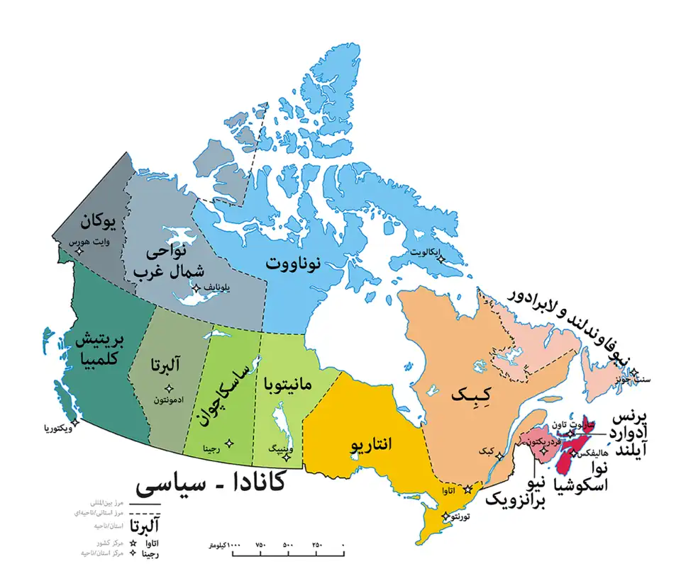
نقشه قابل کلیک کانادا شامل ده استان و سه ناحیه و پایتختهای آنها
نقشه قابل کلیک کانادا شامل ده استان و سه ناحیه و پایتختهای آنها.
با اینکه این منطقهها وضعیت رسمی یا مرزهای معینی ندارند استانها و قلمروهای کانادا are sometimes informally grouped into the following منطقه s (generally from west to east):
کرسیها در مجلس سنای کانادا به صورت مساوی در میان چهار منطقه تقسیم شده است: Maritimes, Quebec, Ontario, و the West, به همراه وضعیت ویژه برای نیوفاندلند و لابرادور, و شمال کانادا ('the North').
Interprovincial regions
فرانسوی-کانادایی English Canada, sometimes known as the Rest of Canada (excluding Quebec) when considering topics of language
The provinces and territories are all sub-divided into regions for a variety of official and unofficial purposes. In some provinces, the regions have been officially defined by their respective governments. In others, the "regions" have no official status.
Regions, and subdivisions of Alberta.
Northern Alberta
Improvement districts
Improvement District No. 24 (Wood Buffalo National Park)
Improvement District No. 349
Municipal Districts
Athabasca County
Big Lakes County
Birch Hills County
Clear Hills County
Municipal District of Fairview No. 136
County of Grande Prairie No. 1
Municipal District of Greenview No. 16
Municipal District of Peace No. 135
Saddle Hills County
Municipal District of Smoky River No. 130
Municipal District of Spirit River No. 133
Regional Municipality of Wood Buffalo (Specialized municipality)
Mackenzie County (Specialized municipality)
Alberta's Rockies
Improvement districts
Improvement District No. 9 (پارک ملی بنف )
Improvement District No. 12 (پارک ملی جاسپر )
Improvement District No. 25 (Willmore Wilderness Park)[ ۳]
Kananaskis Improvement District
Municipal Districts
Municipal District of Bighorn No. 8
جاسپر (Specialized municipality)
Southern Alberta
Improvement Districts
Improvement District No. 4
Municipal Districts
اکادیا شماره ۳۴، البرتا Cardston County
Cypress County
County of Forty Mile No. 8
Kneehill County
County of Newell
Municipal District of Pincher Creek No. 9
Municipal District of Ranchland No. 66
Starland County
Municipal District of Taber
Vulcan County
County of Warner No. 5
Wheatland County
Municipal District of Willow Creek No. 26
Cowsnest Pass (Specialized municipality)
Special Areas
Special Area No. 2
Special Area No. 3
آلبرتای مرکزی
Improvement districts
Improvement District No. 13 (Elk Island National Park)
Municipal districts
County of Barrhead No. 11
Beaver County
Municipal District of Bonnyville No. 87
Brazeau County
Camrose County
Flagstaff County
Lac Ste. Anne County
Lacombe County
Lamont County
County of Minburn No. 27
Mountain View County
County of Paintearth No. 18
Ponoka County
Municipal District of Provost No. 52
Red Deer County
Smoky Lake County
County of St. Paul No. 19
County of Stettler No. 6
Thorhild County
County of Two Hills No. 21
شهرستان ورمیلیون ریور، آلبرتا Municipal District of Wainwright No. 61
Westlock County
County of Wetaskiwin No. 10
Woodlands County
Yellowhead County
Special Areas
منطقه کلگری
Municipal districts
Municipal District of Foothills No. 31
Rocky View County ادمونتون منطقه متروپولیتن
Municipal districts
Leduc County
Parkland County
Sturgeon County
Strathcona County (Specialized municipality)
Calgary–Edmonton Corridor
British Columbia Interior
North Interior
Atlin District
Stikine Country
Peace River Country
Central Interior
South Interior
کوتنیز
کوتنیز
East Kootenay
Elk Valley
Columbia Valley
Columbia Country
اوکناگن Boundary
Similkameen
Thompson
Nicola
Bonaparte
Wells Gray-Clearwater
Shuswap
Lillooet-Fraser Canyon
British Columbia Coast
ساحل جنوبی
لوئر مینلند
Sea-to-Sky Corridor
Pemberton Valley (also part of Lillooet Country)
Gates Valley (also part of Lillooet Country)
Sunshine Coast
جزیره ونکوور
South Island
Greater Victoria
Saanich Peninsula
Western Communities Cowichan Valley (Also part of Mid-Island extended administrative region)
Chemainus River Valley (Also part of Mid-Island extended administrative region)
Mid-Island
جزیره شمالی
Quatsino Sound
Cape Scott
Queen Charlotte Strait
Johnstone Strait
ساحل غربی جزیره ونکوور
Kyuquot Sound
Nootka Sound
Clayoquot Sound
Barkley Sound
Alberni Valley
Juan de Fuca region
Gulf Islands
Southern Gulf Islands
Northern Gulf Islands ساحل مرکزی
Queen Charlotte Strait
Bella Coola Valley
ساحل شمالی
Haida Gwaii (formerly Queen Charlotte Islands)
Skeena
Nass
Stewart Country
Northern
Interlake
Central Plains
Eastman
Westman
Winnipeg Capital Region
Parkland
Pembina Valley
Acadian Peninsula
North Shore
Gulf Shore
Fundy Shore
Fundy Isles
Kennebecasis River Valley
Republic of Madawaska
Miramichi Valley
St. John Valley
Tantramar
Greater Shediac
گریتر مانکتان سنت جان فردریکتون
لابرادور
Labrador West
Labrador Coast
Nunatsiavut نیوفاندلند
Avalon Peninsula
Burin Peninsula
Bonavista Peninsula
South Coast
West Coast
Bay of Islands
Bay St. George
Bay St. George South
Port au Port Peninsula
Great Northern Peninsula
Northeast Coast
Administrative of نواحی شمال غرب.[ ۴]
Inuvik Region
Sahtu Region
Dehcho Region
North Slave Region
South Slave Region
Annapolis Valley
جزیره کیپ برتون
Industrial Cape Breton
Cape Breton Regional Municipality (CBRM)
Cape Breton Highlands
Strait of Canso Area Central Nova Scotia
Eastern Shore
هلیفکس، نوا اسکوشیا (HRM)
North Shore
South Shore
Kitikmeot Region
Kivalliq Region
Qikiqtaaluk Region
Northern Saskatchewan
Southern Saskatchewan
East Central Saskatchewan
زیربخشها
منطقهها Census divisions
Census agglomerations
Municipalities
Municipal districts (counties)
Specialized municipalities
School authorities Communities
Cities
Towns
Villages
Summer villages
Hamlets
Indian reserves and settlements
Metis settlements
Ghost towns
Designated places شهرها و urban
پیوند به مقالههای مرتبط
الگو:جغرافیای کانادا
فهرست مناطق آمریکای شمالی
کشورهای مستقل
آنتیگوا و باربودا •
ایالات متحده آمریکا •
باهاما •
جمهوری دومینیکن •
السالوادور •
باربادوس •
بلیز •
پاناما •
ترینیداد و توباگو •
جامائیکا •
دومینیکا •
سنت کیتس و نویس •
سنت لوسیا •
سنت وینسنت و گرنادین •
کاستاریکا •
کانادا •
کوبا •
گرنادا •
گواتمالا •
مکزیک •
نیکاراگوئه •
هائیتی •
هندوراس
سرزمینها و
آنگویلا •
آروبا •
برمودا •
بونیر •
جزایر ویرجین بریتانیا •
جزایر کیمن •
کوراسائو •
گرینلند •
جزیره گوادلوپ •
مارتینیک •
مونتسرات •
پورتوریکو •
سنت بارثلمی •
سنت مارتین •
سن-پیر و میکلون •
سابا •
سینت اوستاتیوس •
سنت مارتین فرانسه •
جزایر تورکس و کایکوس •
جزایر ویرجین ایالات متحده آمریکا
زیربخشها
مناطق Census divisions
SARM divisions
Municipalities
Rural municipalities جوامع
Cities
Towns
Villages
Resort villages
Hamlets
Indian reserves
Ghost towns شهرها ساسکاچوان
فرهنگ
اقتصاد
جاذبههای گردشگری
Geography
Government
History
زیربخشها
Counties
Parishes
Municipalities
Rural communities
Local service districts
Municipal amalgamations
Communities
First Nations
School districts
مناطق شهرها
.svg.png)